
After making landfall for the fifth time in Batangas province, severe tropical storm Paeng will make its way to the Cavite-Metro Manila-Bataan area on Saturday, according to PAGASA.
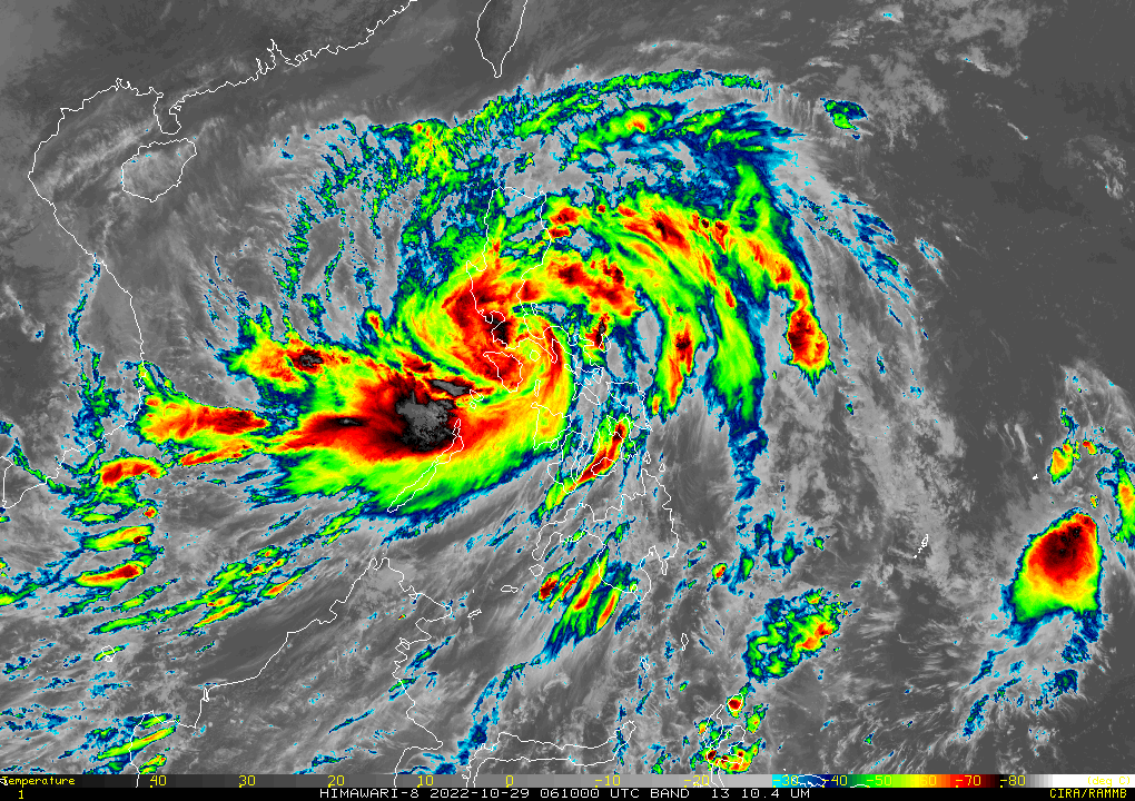
According to the weather bureau’s 2 p.m. As forecast, Paeng was last spotted over the coastal waters of San Juan, Batangas, with maximum sustained winds of 95 kilometers per hour and gusts of 130 kilometers per hour. bulletin.
“Paeng will make landfall near San Juan, Batangas, before moving through the Cavite-Metro Manila-Bataan Peninsula area for the rest of the day”, according to PAGASA.
The weather service issued Signal No. 3 in the following areas, where winds of 89 to 117 kilometers per hour are expected in the next 18 hours.
Luzon
Metro Manila
Bataan
Southern portion of Zambales (Olongapo City, Subic, Castillejos, San Antonio)
Marinduque
Northern and central portions of Quezon (Pitogo, Lucena City, Pagbilao, Infanta, Tiaong, Unisan, Plaridel, San Antonio, Candelaria, Lucban, Sampaloc, Padre Burgos, Sariaya, City of Tayabas, Mauban, Dolores, General Nakar, Agdangan, Gumaca, Atimonan, Real, Macalelon, General Luna, Catanauan) including Pollilo Islands
Laguna
Batangas
Cavite
Rizal
Northwestern portion of Occidental Mindoro (Paluan, Abra de Ilog) including Lubang Islands
Northern portion of Oriental Mindoro (San Teodoro, Puerto Galera, Baco, City of Calapan, Naujan)
Signal number two has been issued in the following areas, where winds of 62 to 88 kph are expected in the next 24 hours.
Luzon
Southern portion of Aurora (San Luis, Baler, Dingalan, Maria Aurora)
Bulacan
Nueva Ecija
Pangasinan
Pampanga
Tarlac
Rest of Zambales
Western and northwestern portions of Camarines Sur (Siruma, Tinambac, Ocampo, Goa, Lagonoy, Milaor, Nabua, Buhi, Baao, Bato, Camaligan, Pili, Tigaon, Garchitorena, Iriga City, San Fernando, Magarao, Minalabac, Balatan, Naga City, Calabanga, Bombon, Bula, Canaman, Saglay, San Jose, Gainza, Sipocot, Del Gallego, Ragay, Lupi, Pasacao, Cabusao, Libmanan, Pamplona)
Rest of Oriental Mindoro
Rest of Occidental Mindoro
Romblon
Camarines Norte
Rest of Quezon
Northern and central portions of Albay (Tiwi, Malinao, Libon, City of Tabaco, Polangui, Oas, City of Ligao, Guinobatan, Pio Duran)
Burias Island
Visayas
Northwestern portion of Antique (Libertad, Pandan, Caluya Islands)
Western portion of Aklan (Buruanga, Malay, Nabas, Ibajay, Tangalan, Makato, Numancia, Lezo)
Signal number one. Winds of 39 to 61 kph are expected in the next 36 hours in the following areas.
Luzon
Isabela
Nueva Vizcaya
Quirino
La Union
Kalinga
Abra
Benguet
Ifugao
Mountain Province
Ilocos Sur
Rest of Aurora
Catanduanes
Rest of Camarines Sur
Rest of Albay
Sorsogon
Rest of Masbate including Ticao Island
Northern portion of Palawan (El Nido, Taytay, Dumaran, Araceli, Roxas, San Vicente) including Calamian Islands and Cuyo Islands
Visayas
Northern and central portions of Eastern Samar (Quinapondan, Can-Avid, Lawaan, Maslog, Balangiga, City of Borongan, San Policarpo, Taft, Llorente, Maydolong, Dolores, Giporlos, Jipapad, Oras, Arteche, Balangkayan, Sulat, San Julian, General Macarthur, Hernani)
Samar
Northern Samar
Leyte
Northern and central portions of Cebu (Daanbantayan, Medellin, San Remigio, Tabogon, City of Bogo, Borbon, Tabuelan, Sogod, Catmon, Tuburan, Carmen, Danao City, Asturias, Balamban, Compostela, Liloan, Cebu City, Mandaue City, Consolacion, Toledo City, City of Talisay, City of Naga, Pinamungahan, Minglanilla, Aloguinsan, San Fernando, City of Carcar, Barili, Sibonga, Dumanjug, Argao, Alcantara, Moalboal, Ronda, Lapu-Lapu City, Cordova, Badian, Dalaguete) including Bantayan and Camotes Islands
Biliran
Northern portion of Bohol (Talibon, Getafe, Buenavista, Inabanga, Clarin, Tubigon, Calape, Bien Unido, Loon)
Negros Occidental
Northern and central portions of Negros Oriental (City of Guihulngan, Vallehermoso, Canlaon City, La Libertad, Jimalalud, Tayasan, Bais City, City of Bayawan, Manjuyod, Basay, Bindoy, Mabinay, Ayungon, City of Tanjay)
Guimaras
Rest of Antique
Rest of Aklan
Capiz
Iloilo
HEAVY RAINFALL
PAGASA said on Saturday that Paeng would bring heavy to torrential rains to Metro Manila, Calabarzon, Bicol Region, Marinduque, Romblon, Mindoro Provinces, and the northern portion of Palawan, including the Calamian and Cuyo Islands.
Rains ranging from moderate to heavy, and at times intense, are expected over the Cagayan Valley, Cordillera Administrative Region, Western Visayas, and Central Luzon.
It also stated that rains ranging from light to moderate to heavy are possible over the rest of Luzon and Visayas.
By Sunday, PAGASA had issued a warning that moderate to heavy rains, with occasional heavy downpours, would hit Zambales, Bataan, and Ilocos Region. Over Metro Manila, Mimaropa, Calabarzon, and the rest of Central Luzon, rains will be light to moderate, with heavy rains possible at times.
“Under these conditions, widespread flooding and rain-induced landslides are expected,” it said.
PAGASA warned that Paeng could cause storm surges of up to 2 meters in low-lying and exposed coastal areas of western Pangasinan, Zambales, Bataan, southern Aurora, Quezon, including the Polillo Islands, Bulacan, Metro Manila, Cavite, Batangas, Marinduque, Camarines Norte, Camarines Sur, and Albay.
Paeng is moving west northwestward at 15 kph and could weaken into a tropical storm as it moves over the Luzon landmass, according to the weather service.
However, once it reaches the West Philippine Sea, it may re-intensify into a severe tropical storm. On Monday, it will leave the Philippine area of responsibility.
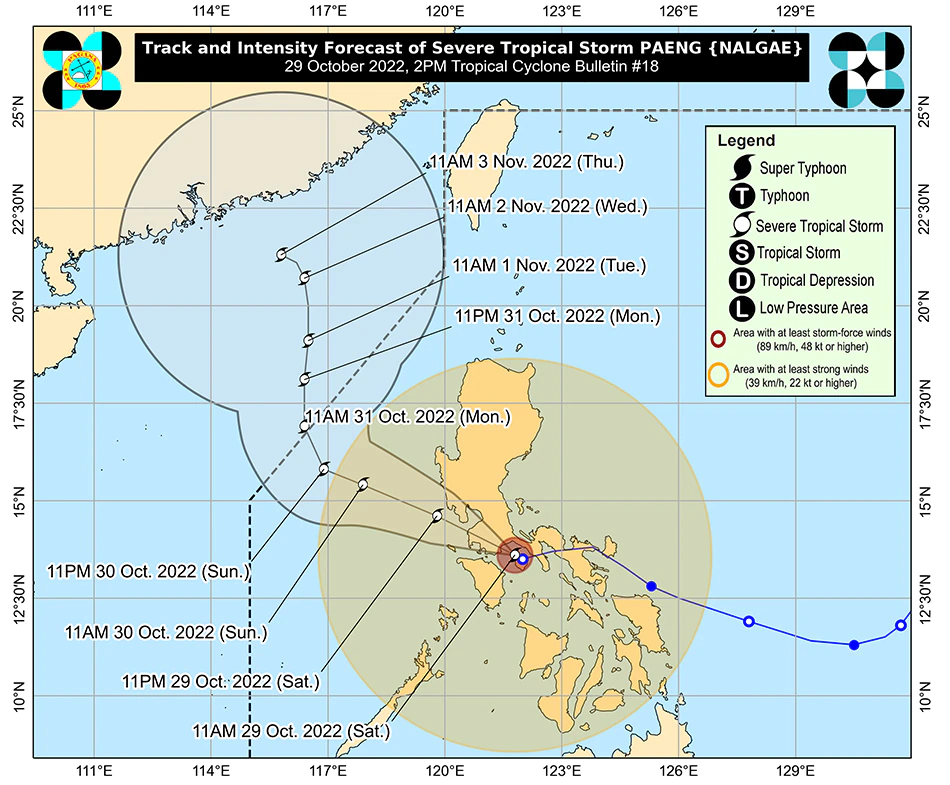
“Paeng will make landfall near San Juan, Batangas before traversing the Cavite-Metro Manila-Bataan Peninsula area for the rest of the day,” according to PAGASA.


