PAGASA issued Signal No. 3 over the National Capital Region (NCR) and nine other areas on Saturday as Severe Tropical Storm Paeng maintained its strength while moving across the northern portion of Marinduque.
It’s 11 a.m. PAGASA stated in its bulletin that the following areas were under Tropical Cyclone Wind Signal (TCWS) No. 3:
- Metro Manila
- Marinduque
- the northern and central portions of Quezon (Pitogo, San Andres, Buenavista, Lucena City, San Francisco, Pagbilao, Infanta, Tiaong, Lopez, Catanauan, Mulanay, Unisan, General Luna, Plaridel, Quezon, San Antonio, Alabat, Candelaria, Lucban, Sampaloc, Padre Burgos, Sariaya, City of Tayabas, Macalelon, Mauban, Dolores, General Nakar, Perez, Agdangan, Gumaca, Atimonan, Real, San Narciso, Guinayangan, Calauag) including Pollilo Islands
- Laguna
- Batangas
- Cavite
- Rizal
- Bataan
- the southern portion of Zambales (Olongapo City, Subic, Castillejos, San Antonio)
- Lubang Islands
Winds of more than 89 km/h and up to 117 km/h are expected in at least 18 hours under Signal Number 3.
Signal No. 2, indicating that winds of more than 62 km/h and up to 88 km/h are expected in the next 24 hours, was issued in the following areas:
Luzon
- The northwestern portion of Sorsogon (Pilar, Donsol)
- the western portion of Masbate (Aroroy, Baleno, Mandaon including Burias Island
- Camarines Sur
- Camarines Norte
- Oriental Mindoro
- Occidental Mindoro
- the rest of Quezon
- Romblon
- Nueva Ecija
- Pangasinan
- Albay
- the southern portion of Aurora (San Luis, Baler, Dingalan, Maria Aurora), Bulacan, Pampanga, Tarlac, and the rest of Zambales
Visayas
- The northwestern portion of Antique (Libertad, Pandan, Caluya Islands)
- the western portion of Aklan (Buruanga, Malay, Nabas, Ibajay, Tangalan, Makato, Numancia, Lezo)
Signal No. 1, where winds of 39-61 km/h may be expected in at least 36 hours or intermittent rains may be expected within 36 hours, was raised over the following areas:
Luzon
- Isabela
- Nueva Vizcaya
- Quirino
- Abra
- Kalinga
- Ifugao
- Mountain Province
- Benguet
- Ilocos Sur
- La Union
- the rest of Aurora
- Catanduanes
- the rest of Sorsogon
- the rest of Masbate including Ticao Island
- the northern portion of Palawan (El Nido, Taytay, Dumaran, Araceli, Roxas, San Vicente) including Calamian and Cuyo Islands
Visayas
- Northern Samar
- Samar
- Eastern Samar
- Biliran
- Leyte
- Southern Leyte
- Cebu including Bantayan and Camotes Islands
- Bohol
- Negros Occidental
- Negros Oriental
- Guimaras
- the rest of Aklan
- the rest of Antique
- Capiz
- Iloilo
As a result, heavy to intense rains, at times torrential, are expected over Metro Manila, CALABARZON, Bicol Region, Marinduque, Romblon, Mindoro Provinces, and the northern portion of Palawan, including the Calamian and Cuyo Islands.
Mainland Cagayan Valley, Cordillera Administrative Region, Western Visayas, and Central Luzon will likely experience moderate to heavy rains, with periods of intense rain, while the rest of Luzon and the Visayas will experience light to moderate rains with periods of intense rain.
Furthermore, the Northeast Monsoon surge, aided by Paeng, will bring strong winds with gale-force gusts over Batanes, Babuyan Islands, Ilocos Norte, the northern and eastern portions of mainland Cagayan, and the northern portion of Apayao.
Coastal inundation
According to PAGASA, there is a low to moderate risk of storm surge of up to 2.0 meters in height, which could cause inundation or flooding in low-lying and exposed coastal areas of western Pangasinan, Zambales, Bataan, southern Aurora, Quezon (including the Polillo Islands), Bulacan, Metro Manila, Cavite, Batangas, Marinduque, Camarines Norte, Camarines Sur, and Albay.
Hazards on coastal waters
Under the influence of the Northeast Monsoon surge and Severe Tropical Storm Paeng, a marine gale warning remains in effect for the seaboards of Luzon and Visayas, as well as the eastern seaboard of Mindanao.
Track and intensity outlook
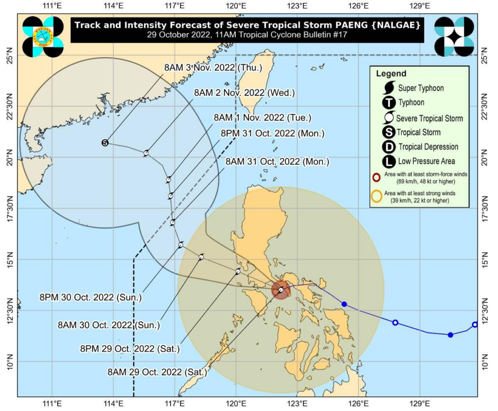
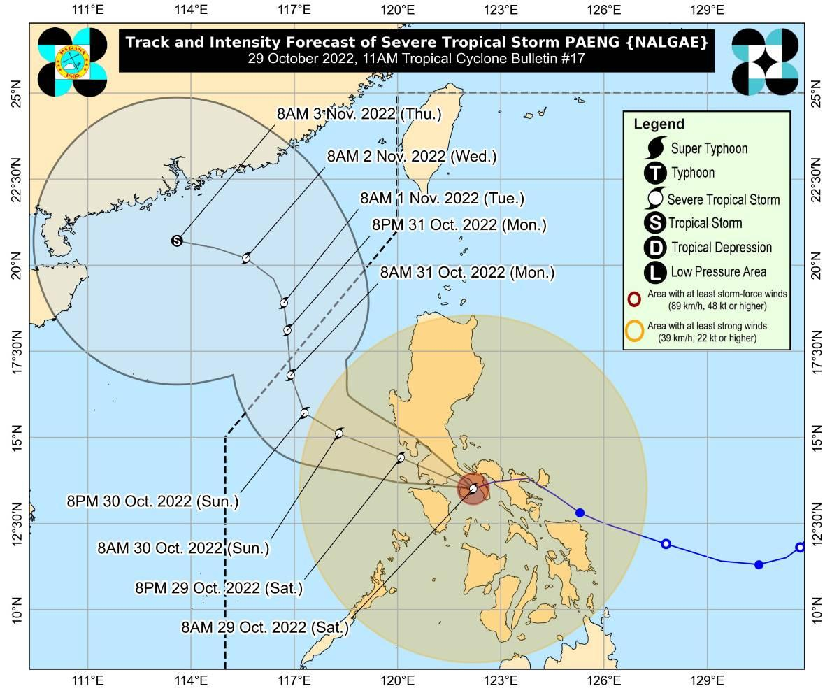
According to PAGASA, Severe Tropical Storm Paeng is expected to track westward in the short term before moving west northwestward across Luzon on Sunday.
According to the forecast track, the center of PAENG will make landfall in the southeastern part of Batangas before moving through the Cavite-Metro Manila-Bataan Peninsula area for the rest of the day. However, a southward shift in PAENG’s forecast track is possible in resulting bulletins.
Due to frictional effects, Paeng may weaken into a tropical storm as it moves over the Luzon landmass, according to PAGASA. Paeng, on the other hand, has the potential to re-intensify into a severe tropical storm once it reaches the West Philippine Sea.
Severe Tropical Storm Paeng’s center was estimated using all available data, including that from the Tagaytay Doppler Weather Radar near Mogpog, Marinduque (13.5 °N, 121.9 °E).
It is moving west southwestward at 25 km/h, with maximum sustained winds near the center of 95 km/h and gustiness of up to 130 km/h.


