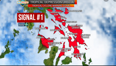
The Philippine Atmospheric, Geophysical, and Astronomical Services Administration (PAGASA) had raised Tropical Cyclone Wind Signal (TCWS) No. 1 over parts of Eastern Samar and Northern Samar due to Tropical Storm Ambo, on Wednesday morning.

Signal No. 1 was raised over the northern portion of Eastern Samar such as (Jipapad, Maslog, Arteche, San Policarpio, Oras, Dolores, Can-avid, Taft, Sulat, San Julian, Borongan City), and the eastern portion of Northern Samar (Lapinig, Gamay, Mapanas, Palapag, Laoang, Catubig, Las Navas).
Storm Ambo further intensified and will bring scattered light to moderate with at times heavy rain showers during thunderstorms over Eastern Visayas.
Meanwhile, residents in these areas were advised to take precautionary measures, coordinate with local disaster risk reduction and management offices, and continue monitoring for updates, especially the local rainfall or thunderstorm advisories and heavy rainfall warnings from PAGASA Regional Services Divisions (PRSD).
Also, flooding and rain-induced landslides may occur in highly to very highly susceptible areas during heavy or prolonged rainfall.
Rough seas will be experienced over the eastern seaboard of Bicol Region and the northern and eastern seaboards of Eastern Visayas on Wednesday. Sea travel is risky over these areas.
The storm is moving north-northwestward over the Philippine Sea east of Samar Island.
In addition, Ambo is forecast to further intensify as it approaches the Eastern Visayas-Bicol Region area.
As of 4 a.m., the center of Tropical Storm Ambo was estimated at 410 kilometers east of Borongan City, Eastern Samar moving north northwest at 15 kilometers per hour.
Ambo packs maximum sustained winds of 85 kph near the center and gustiness of up to 105 kph.
On Thursday, moderate to heavy rains will be experienced in eastern Visayas, Catanduanes, Albay, Sorsogon, and Masbate.
Strong to near-gale force winds associated with the tropical storm will begin affecting the areas under TCWS No. 1 on Thursday afternoon.
What can you say about this? Share it in the discussion box below.


