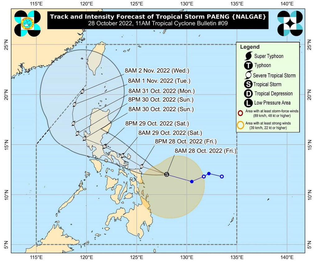
Thirteen areas in Luzon and Visayas were under Tropical Cyclone Wind Signal (TCWS) No. 2 as a result of Tropical Storm Paeng, according to PAGASA, the state weather bureau.
At 11 a.m. PAGASA stated in its bulletin that the following areas are covered by TCWS No. 2:

Luzon
- Catanduanes
- Albay
- Sorsogon
- Masbate including Ticao and Burias Islands
- Camarines Sur
- Camarines Norte
- the central and southern portions of Quezon (Atimonan, Pagbilao, Padre Burgos, Agdangan, Unisan, Plaridel, Gumaca, Pitogo, Macalelon, General Luna, Catanauan, Lopez, Calauag, Quezon, Alabat, Perez, Tagkawayan, Guinayangan, Buenavista, Mulanay, San Narciso, San Andres, San Francisco)
- Marinduque
Visayas
- Northern Samar
- Eastern Samar
- Samar
- the northeastern portion of Leyte (Tacloban City, Babatngon, San Miguel, Barugo),
- Biliran
Meanwhile, TCWS No. 1 covers the following areas in Luzon, Visayas, and Mindanao:
Luzon
- Metro Manila
- Bataan
- Pampanga
- Bulacan
- the southeastern portion of Tarlac (Concepcion, La Paz)
- the central and southern portions of Nueva Ecija (City of Gapan, San Leonardo, Santo Domingo, Rizal, San Isidro, Laur, Zaragoza, Llanera, Aliaga, Palayan City, Gabaldon, General Mamerto Natividad, Cabanatuan City, Quezon, San Antonio, General Tinio, Santa Rosa, Pe, Jaen, Licab, Bongabon, Cabiao, Talavera)
- the southern portion of Aurora (Dingalan, San Luis, Maria Aurora, Baler)
- Cavite
- Laguna
- Batangas
- Rizal
- the rest of Quezon including Pollilo Islands
- Occidental Mindoro including Lubang Islands
- Oriental Mindoro
- Romblon
- Calamian Islands
Visayas
- The rest of Leyte
- Southern Leyte
- the northern and central portions of Cebu (Daanbantayan, Medellin, San Remigio, Tabogon, City of Bogo, Borbon, Tabuelan, Sogod, Catmon, Tuburan, Carmen, Danao City, Asturias, Balamban, Compostela, Liloan, Cebu City, Mandaue City, Consolacion, Toledo City, City of Talisay, City of Naga, Pinamungahan, Minglanilla, Aloguinsan, San Fernando, City of Carcar, Barili, Sibonga, Dumanjug, Argao, Alcantara, Moalboal, Ronda, Badian, Dalaguete, Lapu-Lapu City, Cordova) including Bantayan and Camotes Islands
- Bohol
- the northern and central portions of Negros Occidental (Sagay City, Cadiz City, City of Escalante, Manapla, Enrique B. Magalona, City of Victorias, Silay City, City of Talisay, Murcia, Bacolod City, Bago City, Pulupandan, Valladolid, La Carlota City, La Castellana, San Enrique, Pontevedra, Hinigaran, Moises Padilla, Isabela, San Carlos City, Salvador Benedicto, Calatrava, Toboso, Binalbagan, City of Himamaylan)
- the northern portion of Negros Oriental (City of Guihulngan, Vallehermoso, Canlaon City, La Libertad, Jimalalud, Tayasan)
- Guimaras
- Aklan
- the northern and central portions of Antique (Libertad, Pandan, Sebaste, Culasi, Tibiao, Barbaza, Laua-An, Bugasong, Valderrama, Patnongon, San Remigio, Caluya Islands)
- Capiz
- the northern and central portions of Iloilo (Calinog, New Lucena, Maasin, Estancia, Batad, Oton, Concepcion, Pavia, Duelas, Balasan, Barotac Nuevo, Ajuy, Iloilo City, Anilao, San Dionisio, San Miguel, Mina, Santa Barbara, Barotac Viejo, Leganes, Carles, Dingle, Zarraga, Bingawan, Cabatuan, Alimodian, Dumangas, San Rafael, San Enrique, Badiangan, Banate, City of Passi, Pototan, Lambunao, Lemery, Sara, Janiuay, Leon, Tigbauan, Tubungan, Igbaras, Guimbal)
Mindanao
- Dinagat Islands
- Surigao del Norte including Siargao and Bucas Grande Islands
- the northern portion of Surigao del Sur (Carrascal, Cantilan, Madrid, Carmen, Lanuza, Cortes, City of Tandag, Bayabas, Tago, Cagwait)
- the northern portion of Agusan del Norte (Kitcharao, Jabonga, Santiago)
Paeng was last seen 220 kilometers east northeast of Borongan City, Eastern Samar, or 305 kilometers east of Catarman, Northern Samar, with maximum sustained winds of 75 kilometers per hour and gustiness of up to 90 kilometers per hour, moving westward at 25 kilometers per hour, according to PAGASA.
According to PAGASA, it will continue to move west northwestward through Sunday.
Paeng is expected to make landfall over Catanduanes early Saturday morning, then pass through the northern portion of Camarines Sur and the eastern portion of Camarines Norte.
Paeng could make another landfall over the east coast of Quezon (including the Polillo Islands) or Aurora by Sunday morning.
Paeng is expected to intensify further as it moves over the warm waters of the Philippine Sea, and it could reach the category of severe tropical storm within 24 hours, according to PAGASA.
Because of the possibility of a landfall over Bicol, PAGASA believes it is less likely to reach typhoon strength and is more likely to remain a severe tropical storm.
Floods
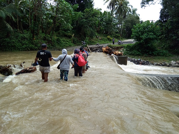
Meanwhile, according to a Unang Balita report on Friday, some areas in Bicol and Visayas have already experienced chest-deep floods as a result of Paeng’s rains.
In Camarines Sur, 17 barangays in Libmanan were flooded with knee-high water, while Barangay San Agustin in Bula was flooded with waist-high water that entered some houses.
Over 100 people were evacuated from landslide and rainfall areas in Libmanan and Calabanga, according to the Office of Civil Defense Region 5.
Some landslides have been reported in the barangays of Pangsangaan and Sta. According to the Municipal Disaster and Risk Reduction Management Office in Presentacion town, Maria (MDRRMO).
Knee-deep floods in Aklan hit Barangay Poblacion in Libacao town and entered some homes. Oquendo Elementary School in Balete was flooded by a chest-high flood.
A bridge in Madalag town also overflowed with water.

Suspended sea cruises
As this unfolded, the Philippine Coast Guard (PCG) announced on Friday that more sea trips would be canceled due to the threat of Tropical Storm Paeng.
The Coast Guard Station (CGS) in Central Cebu, Camotes, Eastern Bohol, and Western Leyte issued a notice prohibiting all types of seacraft from traveling in areas under Tropical Cyclone Wind Signal.
The CGS Capiz also delayed all trips from Roxas City to Romblon and vice versa.
Meanwhile, the CGS Ilocos Norte has delayed small seacraft trips along the province’s northern and western seaboards. Larger vessels, on the other hand, were warned of the impending storm.
The PCG monitored moderate to rough seas in Bicol and Eastern Visayas from 12 a.m. to 4 a.m. There were 989 passengers, drivers, and cargo helpers stranded, as well as 478 rolling cargoes and 11 vessels.
According to the PCG, 42 vessels and six motorbancas have taken shelter in Bicol and Eastern Visayas due to Paeng.


