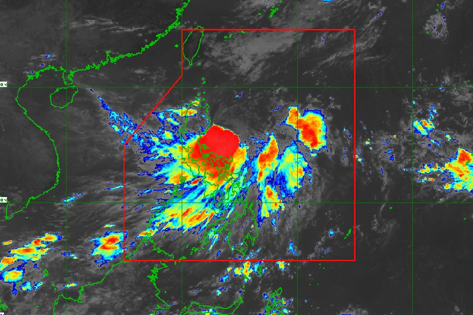
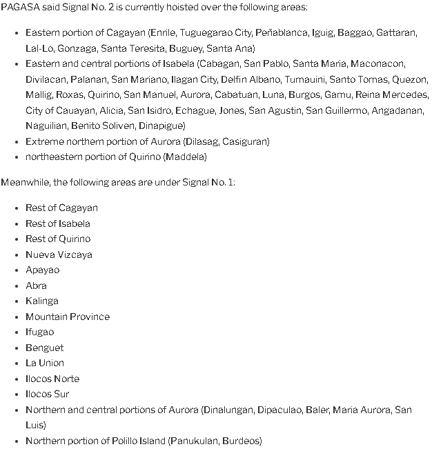
Florita has strengthened into a tropical storm, according to PAGASA, causing the state meteorological service to issue Signal No. 2 for many locations in Luzon.
It’s 11 a.m. Florita was packing winds of 75 kilometers per hour in the center, with gusts of up to 90 kilometers per hour, according to a PAGASA report. At 8 a.m., it became a tropical storm.
Its center was 215 kilometers east of Casiguran, Aurora, and it was traveling west-southwestward at 15 kilometers per hour.
Florita is expected to make landfall Tuesday afternoon around the east coast of Cagayan or northern Isabela and may cross the Babuyan Channel.
The agency cautioned that “further strengthening is expected prior to its impact.”
Tropical storm wind warnings warn residents to prepare for damage to structures, plants, and agricultural crops.
According to PAGASA, Cagayan, Isabela, Batanes, Aurora, Ilocos Norte, Ilocos Sur, and La Union will continue to suffer light to moderate to heavy rainfall on Monday as a result of Florita’s impacts.
The Cagayan provincial administration issued a suspension of schools from pre-school to elementary level for the whole province owing to the terrible weather, according to the National Disaster Risk Reduction and Management Council.
Suspension of lessons up to the secondary level was specifically proclaimed in the municipalities of Alcala and Baggao.
On Tuesday, Florita is expected to produce heavy to severe rains, at times torrential, across Cagayan, Isabela, Batanes, Cordillera Administrative Region, and Ilocos Region, while moderate to heavy rains are expected over the northern sections of Aurora, Zambales, Bataan, and the remainder of the Cagayan Valley.
On the same day, rainfall ranging from light to moderate to heavy will fall throughout the rest of Central Luzon.
According to PAGASA, the Southwest Monsoon (Habagat) will also deliver precipitation to Southern Luzon and Central Visayas.
“Under these conditions, scattered to widespread flooding (including flash floods) and rain-induced landslides are expected especially in areas that are highly or very highly susceptible to these hazard as identified in hazard maps, and in localities with significant antecedent rainfall,” According to the state weather bureau.
PAGASA’s next advisory will be issued at 5 p.m.


