On Monday morning, February 22 update of Typhoon Auring, the Philippine Atmospheric, Geophysical and Astronomical Services Administration (PAGASA) said that Typhoon Auring weakens to tropical depression but continues its effect of bringing moderate to heavy rains that is expected to experience on the areas including Bicol region, Northern Samar, Samar, Eastern Samar, Biliran, Leyte, Marinduque, Romblon, and Quezon. Light to moderate with at times heavy rains over Aurora and the rest of Visayas, Mimaropa, and Calabarzon.
PAGASA warned that heavy or prolonged rainfall in the affected areas may occur scattered flooding including flash floods and landslides, the weather agency said.
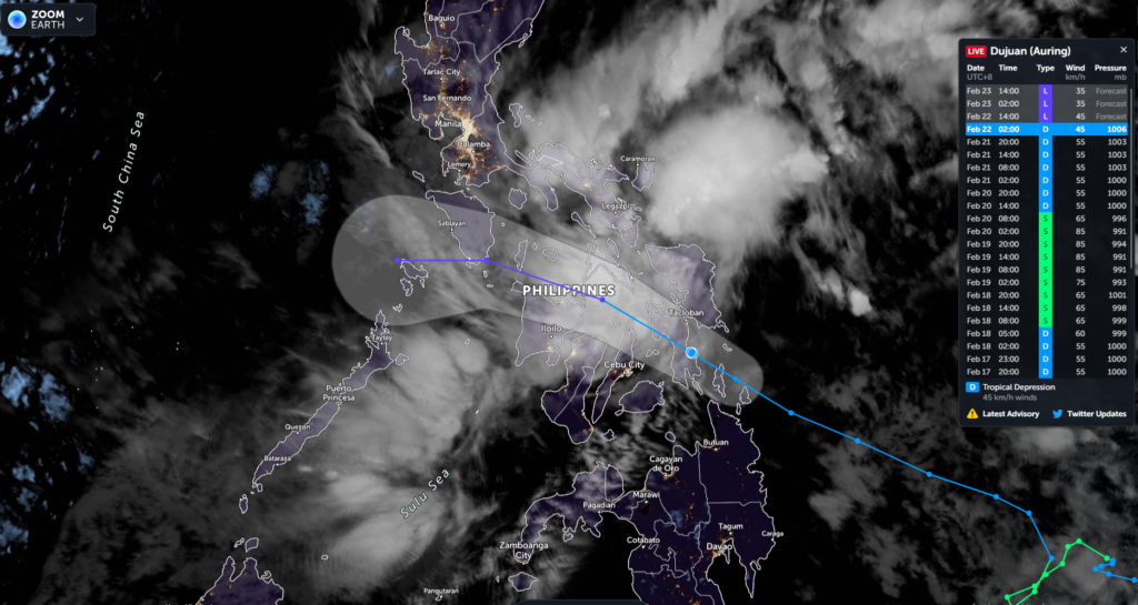
Track Monitoring Tropical Depression “Auring”
The areas affected and placed under tropical cyclone, according to PAGASA, may experience wind signal no. 1 where 30 to 60 kph winds in 36 hours were expected to affect the following places:
LUZON
- Sorsogon
- Masbate including Ticao and Burias Islands
- Albay
- Catanduanes
- eastern portion of Camarines Sur (Caramoan, Presentacion, Sagnay, Buhi, Iriga City, Nabua, Bato, Balatan)
VISAYAS
- Northern Samar
- Eastern Samar
- Samar
- Biliran
- Leyte
- Southern Leyte
- Bohol
- Cebu
- Siquijor
- northern and eastern portions of Negros Oriental (Dumaguete City, Sibulan, San Jose, Amlan, Pamplona, Tanjay City, Bais City, Manjuyod, Bindoy, Ayungon, Tayasan, Jimalalud, La Libertad, Guihulngan City, Canlaon City, Vallehermoso)
- northern and central portions of Negros Occidental (Binalbagan, Isabela, Moises Padilla, La Castellana, La Carlota City, Bago City, Pontevedra, Hinigaran, San Enrique, Valladolid, Pulupandan, Murcia, San Carlos City, Bacolod City, Salvador Benedicto, Calatrava, Talisay City, Silay City, Enrique B. Magalona, Victorias City, Manapla, Cadiz City, Sagay City, Escalante City, Toboso)
- eastern portion of Iloilo (Dumangas, Barotac Nuevo, Anilao, San Rafael, Barotac Viejo, Banate, Passi City, San Enrique, Dingle, Lemery, Ajuy, Sara, Concepcion, San Dionisio, Batad, Estancia, Balasan, Carles)
- eastern portion of Capiz (Cuartero, Dumarao, Ma-Ayon, Pontevedra, Panay, President Roxas, Panitan, Dao, Pilar)
MINDANAO
- Dinagat Islands
- Surigao del Norte
- northern portion of Surigao del Sur (Lianga, Barobo, San Agustin, Marihatag, Cagwait, Bayabas, Tago, San Miguel, Tandag City, Cortes, Lanuza, Carmen, Madrid, Cantilan, Carrascal), Agusan del Norte, the northern portion of Agusan del Sur (Bayugan City, Prosperidad, Sibagat)
- eastern portion of Misamis Oriental (Gingoog City, Magsaysay, Medina, Talisayan, Claveria, Balingasag, Lagonglong, Balingoan, Kinoguitan, Sugbongcogon, Binuangan, Salay)
- Camiguin
PAGASA added that the occasional higher gusts maybe occurring duo to the combined effects of the northeast monsoon and strong breeze from Auring. This will probably hit areas under TCWS no. 1, as well as over the southern portion of Aurora, Quezon, Marinduque, Romblon, Oriental Mindoro, Cuyo Islands, Cagayancillo Islands, and the rest of Visayas and Bicol Region.
PAGASA reminds mariners using small seacraft to avoid navigating under these conditions until safety is ensured.


