Bagyong Ruby (Hagupit) updates as of December 5, 2014, Friday, given by the Weather of Bureau, Philippine Atmospheric, Geophysical and Astronomical Services Administration (PAGASA). On their latest forecast and advisory, PAGASA has continues monitoring through their Typhoon Tracking Device and issued the Public Storm Warning Signals.
 According to their report as of Friday, December 05, 2014 PAGASA has issued weather bulletin forecast for Bagyong Ruby (Hagupit) to warn the affected areas.
Please check it here on the table below the latest forecast of PAGASA and the Public Storm Warning Signals:
| Signal No. 2 (winds of 61-100 kph expected at least 24 hrs) | |
| LUZON | |
| Sorsogon | |
| Ticao Island | |
| Masbate | |
| VISAYAS | |
| Northern Samar | |
| Eastern Samar | |
| Samar | |
| Biliran | |
| Leyte | |
| Southern Leyte | |
| Northern Cebu | |
| Cebu City | |
| Bantayan Island | |
| Camotes Island | |
| MINDANAO | |
| Surigao del Sur | |
| Agusan del Norte | |
| Surigao del Norte | |
| Dinagat Island | |
| Siargao Island | |
| Signal No. 1 (winds of 30-60 kph expected at least 36 hours) | |
| LUZON | |
| Catanduanes | |
| Albay | |
| Camarines Norte | |
| Camarines Sur | |
| Burias Island | |
| Romblon | |
| VISAYAS | |
| Capiz | |
| Iloilo | |
| Negros Oriental | |
| Negros Occidental | |
| Rest of Cebu | |
| Siquijor | |
| Bohol | |
| MINDANAO | |
| Misamis Oriental | |
| Agusan del Sur | |
| Camiguin Island | |
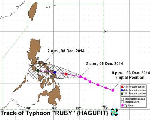
According to PAGASAG, Bagyong Ruby (Hagupit) is gradually moving towards Eastern Visayas with slightly increasing its strength as the storm is about to make its landfall which is estimated on the evening time of Saturday, December 5, 2014 or during the morning time of Sunday, as the typhoon is getting slower of its movement from the Pacific Ocean. The expected area of its landfall was tracked to hit the Eastern Samar.
Early of this morning, Saturday, December 5, 2014 Bagyong Ruby (Hagupit) is tracked near the east of Borongan, Eastern Samar with 215 kph maximum sustained winds. The typhoon is slowly moving towards southeast of Catarman, Northern Samar on Sunday morning.


