The Philippine Atmospheric Geophysical and Astronomical Services Administration (PAGASA) has officially published the ’24 Hour Public Weather Forecast’ this morning about the Low Pressure Area (LPA) that enters the Philippine Areas of Responsibility today January 10, 2014. Duration of the report covers the period from 5:00 a.m. January 10, 2014 to 5:00 a.m. January 11, 2014. If the said Low Pressure Area will be developed into a typhoon, the name will be called “Agaton.”
 Agaton will be the first typhoon spotted in the Philippine Area of Responsibility this year 2014. According to the previous report, “Agaton” was feared to become a ‘Super Typhoon Yolanda 2’ which report became alarming and goes viral in social media. But according to the weather bureau of PAGASA and TV5 report, the said ‘Agaton’ or the ‘Super Typhoon Yolanda 2’ is just a hoax and the there is nothing worry about.
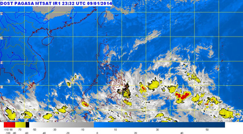
PAGASA weather forecaster Buddy Javier told ABS-CBN News that the Low Pressure Area spotted about 1,460 KM East of Southern Mindanao (4.00N, 139.50E) as of 4:00 a.m. The Low Pressure is expected to enter the Philippine Area of Responsibility but will not make a landfall.
“Sa mga analysis namin, babaybay lang ito dito sa eastern section ng bansa. Hindi siya direktang magla-landfall. Babaybay lang, paakyat din,” Javier told dzMM.
According to PAGASA, the northeast monsoon or ‘Amihan’ continue affecting some areas of Luzon. The Visayas and Mindanao areas will be experiencing a cloudy sky with light to moderated rains and thunderstorms, while the rest of Luzon provinces including Manila are cloudy to cloudy skies with isolated rains.
Related Article: Update of AGATON as of 5:00 p.m of January 11 – 5:00 a.m. of January 12, 2014
Related Article: Super Typhoon Yolanda 2 “Agaton” is Hoaxed.