Tropical Depression “ATSANI” & Rolly in the Philippines Latest Updates | October 31, 2020. Tropical Depression “Atsani” Maintains Its Strength as it Moves Northwestward. The center of Tropical Depression “ATSANI” was estimated based on all available data at 1,655 km East of Southern Luzon (OUTSIDE PAR)(13.4°N,139.5°E).
The maximum sustained winds are 55 km/h near the center and the gustiness up to 70 km/h while the movement at 25 km/h. ATSANI” will move generally northwestward today through Tuesday morning. It will turn slowly westward then west-southwestward on Tuesday afternoon before it begins to slightly accelerate west-southwestward on Wednesday. It is forecast to enter the Philippine Area of Responsibility (PAR) tomorrow afternoon.
For Tropical Depression “Atsani:”
Forecast Positions and Intensities
Tomorrow morning
01 November 2020 1,440 km East of Central Luzon (Casiguran, Aurora) (OUTSIDE PAR) (16.2°N, 135.6°E)
Tropical Storm
Monday morning
02 November 2020 885 km Northeast of Virac, Catanduanes (18.3°N, 130.9°E)
Severe Tropical Storm
Tuesday morning
03 November 2020 810 km East of Aparri, Cagayan (19.1°N, 129.3°E)
Typhoon
Wednesday morning
04 November 2020 720 km East of Calayan, Cagayan (18.9°N, 128.3°E)
Typhoon
Thursday morning
05 November 2020 365 km East of Aparri, Cagayan (18.4°N, 125.1°E)
Typhoon
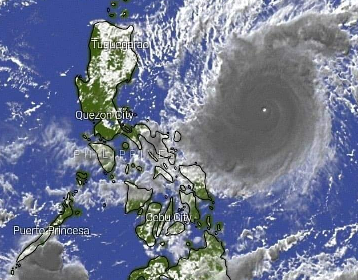
Typhoon “Rolly” Maintains its strength as it threatens Bicol Region. Signal No. 3 is raised in three Bicol areas, while Metro Manila and several other places are under Signal No. 2 due to Typhoon #RollyPH. Here’s a complete list from PAGASA.
“ROLLY” is likely to remain a typhoon category (185-215 km/h) by the time it makes landfall. While traversing over Luzon, “ROLLY” is forecast to weaken considerably and emerge as a severe tropical storm or minimal typhoon over the West Philippine Sea.
Tonight, the outer rainbands of “ROLLY” will bring light to moderate with at times heavy rains over Bicol Region, Visayas, and Quezon. Beginning tomorrow early morning, the passage of Typhoon “ROLLY” will bring heavy to intense rains over Metro Manila, Bicol Region, CALABARZON, Aurora, Bulacan, Zambales, Bataan, Marinduque, Romblon, Occidental Mindoro, and Oriental Mindoro.
At 7:00 PM today, the eye of Typhoon “ROLLY” was located based on all available data at 280 km East Northeast of Virac, Catanduanes (14.3 °N, 126.7 °E ).
SIGNAL no. 4:
Catanduanes and the eastern portion of Camarines Sur (Siruma, Tinambac, Goa, Lagonoy, San Jose, Garchitorena, Presentacion, Caramoan).
signal no. 1; The rest of Zambales, Tarlac, The rest of Nueva Ecija, The rest of Aurora, Pangasinan, La Union, The southern portion of Ilocos Sur Mountain Province, Benguet, Ifugao, Nueva Vizcaya, Quirino
Share your thoughts and comment in the discussion box below.