PAG-ASA released it latest update on the super typhoon “Maysak” that is responsible for destroying multiple homes in Micronesia is now going straight and move closer to the Philippine Area of Responsibility (PAR).
The said typhoon will be expected to landfall upon the celebration of Holy Week Easter Sunday.
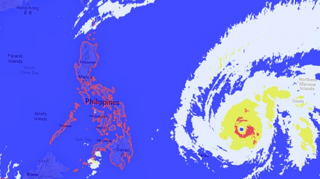
According to the meteorologist Derek William the typhoons official track will be heading straight to Luzon.
But the government assured that the Yolanda incident will not happen again, President P-Noy noted “We are prepared and all hand are on deck”
According to Malacañang spokesman Edwin Lacierda the government is concerned towards the destructive force of this typhoon and prepared for the unexpected situations that may arise this Easter Sunday. He added that the NDDRRMC (National Risk Reduction and Management Council) and PAG-ASA were already on their duty to provide timely update on this expected disaster.
“At the same time, the NDRRMC is, as you know, is composed of several Cabinet agencies, so all of them have already been informed of the incoming storm and insofar as the roles of each Cabinet agency, they know what to do,” Lacierda said.
DILG Secretary Mar Roxas already advise local officials of Visayas and Sounthern Luzon to prepare on advance for the expected entry of Maysak.
Interior Secretary Mar Roxas advise local officials in the Visayas and southern Luzon to prepare for the expected entry of Maysak.
“Even if the typhoon is still far off, our leaders should be ready for its possible onslaught,” Roxas noted
As of now the typhoon is moving west northwest with the sustain winds of 175 kilometers per hour and a gust of 210 kph with a speed of 20 kph.
A cyclone is considered a supertyphoon when its sustained winds reach at least 220 kph, according to Pagasa.


