Typhoon Lawin is now intensified as a super typhoon just this Wednesday afternoon. Lawin is now a potentially destructive cyclone as PAGASA declared that it is continuously moving of extended 225 kilometers per hour (kph) near the center and gusts of up to 315 kph. It’s diameter has expanded to 700 kilometers to 800 kilometers. They warned the provinces that is in the pathway of Lawin to experience heavy and intense rains that may cause flash floods, storm surges and landslides.
Super Typhoon #LawinPH estimated rainfall amount is from moderate to heavy within the 800 km diameter. | via @dost_pagasa pic.twitter.com/wBb7dS5jDh
— ABS-CBN News (@ABSCBNNews) October 19, 2016
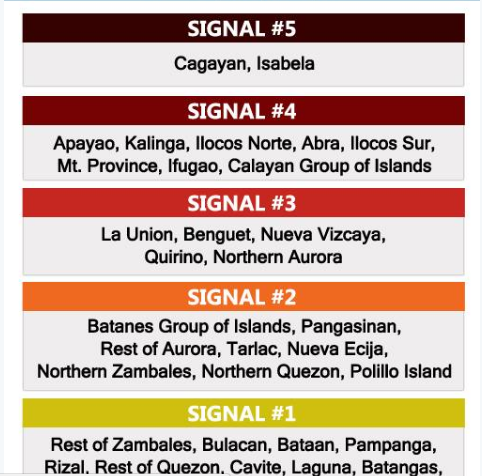
Picture shown below tells the storm signals in the following areas:
As of 2 PM, Tropical cyclone warning signals are hoisted over these areas: #LawinPH pic.twitter.com/631cwLoKgN
— ABS-CBN News (@ABSCBNNews) October 19, 2016
Isabela-Cagayan are expeced to be hit by Lawin between late Wednesday to early Thursday. PAGASA’S Assistant Weather Services Chief, Rene Paciente said that Lawin can brought a lot of destructive winds and rains, even outside of it’s landfall area.
Visit https://t.co/gxOF1RslqZ for the latest updates on #LawinPH. Keep safe, Kapamilya! pic.twitter.com/YbelnzFfrb
— ABS-CBN News (@ABSCBNNews) October 19, 2016
He stated, “Iyung bagyong ito, talagang super strong siya. Kahit saan tatama iyun, talagang destructive siya. Huwag niyo nang anuhin kung saan mag-landfall, kahit tatama siya ng Cagayan o Isabela, destructive pa rin siya dahil sa laki ng diameter ng bagyo natin,”
It has been reported also that Lawin was plotted 300 kilometers east of Casiguran, Aurora at 1 p.m. It may leave the Philippine area of responsibility late Thursday or early Friday.


