The latest update of the Tropical Cyclone “Hagupit” (Bagyong Ruby) as of Thursday morning December 4, 2014, “Hagupit (Ruby)” is continues intensifying into a super typhoon as it is about to make its landfall at the particular area of the Eastern Samar and Leyte by Saturday afternoon or early evening of the same day, December 6, 2015, says the US Navy’s Joint Typhoon Warning Center (JTWC).
 According to JTWC latest update as of today, Thursday, December 04, 2014, Hagupit (Ruby) has entered the Philippine Area of Responsibility (PAR) at around 2 a.m. early this morning with the winds of 130 knots (240.76 kph) and gustiness of 160 knots (296.32 kph).
On the other hand, report from PAGASA and the World Meteorological Organization (WMO), the agency did not officially used the term “Super Typhoon” as applied to Hagupit (Ruby) Typhoon because according to them, “Hagupit (Ruby)” has the wind of 200kph or greater while it can be considered “Super Typhoon” if the wind sustained exceeds more than 220kph.
But, JTWC has indicated with their latest update as of Thursday that the Hagupit (Ruby) Super Typhoon is projected by 2 p.m. on Thursday to have 145 knots of winds or equivalent to 268.54 kph and gustiness of 175 knots or 324.1 kph. JTWC latest forecast of the typhoon “Hagupit (Ruby)”exceeds the minimum category of a “Super Typhoon” with at least 220kph, therefore “Super Typhoon” was named in order to warn the people of the country especially to the area where the “Hagupit (Ruby)” typhoon is expected to make its landfall.
In addition, JTWC indicated that the Typhoon Hagupit (Ruby) is expected to increase the winds up to 160 knots or 296.32 kph with gustiness of 195 knots or 361.14 kph on the following day –Saturday.
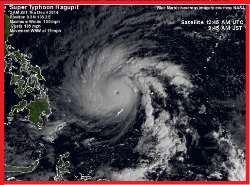
On the other hand, the US’ National Oceanic and Atmospheric Administration (NOAA) issued a satellite image of the Typhoon “Hagupit (Ruby)” as of 6:32 a.m. on Thursday (PHL time) showing that “Hagupit (Ruby)” has already formed a well-defined “eye,” indicating that “Hagupit (Ruby)” a strong typhoon.
The JTWC also indicated that “Hagupit (Ruby)” typhoon is heading for Eastern Visayas, but continues its movement towards to affects the eastern part of Luzon by Sunday.
However, Japan Meteorological Agency forecasted at around 5:45 (Philippine time) early this morning indicating “Hagupit (Ruby)” typhoon is moving north-west with the speed of 30kph and could intensify while “Hagupit (Ruby)” typhoon is about to make its landfall.
Here is the Daily Update of the Hagupit (Ruby) Typhoon:


