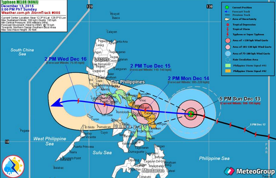
Top Trending Topic online! The Country’s Weather Bureau, the Philippine Atmospheric, Geophysical and Astronomical Services Administration or more popularly known as PAGASA warned the Filipino public that the new typhoon Nona (International name: Melor) has intensified….endangering the Bicol Region and Eastern Visayas. The Potential Landfall Area will be somewhere along the shores of Northern Samar Today (Monday, Dec. 14, 2015) between 11:00 AM to 1:00 PM with a Strike Probability of 80-90 percent.
MELOR (NONA) will enhance the Northeast Monsoon (Hanging Amihan) bringing occasional rain showers with some thunderstorms across the Northern and Eastern Sections of Luzon beginning Monday (Dec 14). Residents are advised to take precautionary measures against possible flashfloods or landslides especially during heavy downpour.
Residents and visitors along Eastern and Southern Luzon incl. Bicol Region and Eastern Visayas should closely monitor the development of TY MELOR (NONA).
PAGASA raised Storm Warning Signal No. 3 (121-170 kph) in six areas of Luzon and Visayas.
Forecast Positions:
- 24 hour (Tomorrow evening): In the vicinity of Donsol, Sorsogon
- 48 hour (Tuesday evening): In the vicinity of Nothern Mindoro
- 72 hour (Wednesday evening): 290 km West Northwest of San Jose, Occidental Mindoro
- 96 hour (Thursday evening): 310 km Northwest of Puerto Princesa City, Palawan
- 120 hour (Friday evening): 575 km West of Puerto Princesa City, Palawan (Outside PAR)
Public Storm Warning Signal No. 03 (121-170 kph Expected in 18hrs.)
LUZON: Catanduanes, Sorsogon, Albay including Ticao Island
VISAYAS: Northern Samar, Eastern Samar and Samar
Impacts of the wind:
- Heavy damage to high–risk structures;
- Moderate damage to medium- risk structures;
- Light damage to low-risk structures
- Increasing damage (up to more than 50%) to old, dilapidated residential structures and houses of light materials. Majority of all nipa and cogon houses may be unroofed or destroyed
- Houses of medium strength materials (old, timber or mixed timber-CHB structures, usually with G.I. roofing’s); some warehouses or bodega-type structures are unroofed.
- There may be widespread disruption of electrical power and communication services.
- Almost all banana plants are downed
- Some big trees (acacia, mango, etc.) are broken or uprooted,
- Dwarf-type or hybrid coconut trees are tilted or downed.
- Rice and corn crops may suffer heavy losses
- Damage to shrubbery and trees with foliage blown off; some large trees blown down.
- Ocean Wave Height: (Open Sea) 14.0 meters Storm surge may reach up to 3.6 meters
Public Storm Warning Signal No. 01 (30-60kph Expected in 36 hrs.)
LUZON: Oriental Mindoro, Batangas, Laguna, Rest of Quezon
VISAYAS: Southern Leyte, Northern Cebu including Bantayan and Camotes Islands, Aklan, Capiz, Northern Negros Occidental
MINDANAO: Dinagat province and Siargao Island
Impacts of the wind:
- Very light or no damage to low risk structures,
- Light damage to medium to high risk structures
- Slight damage to some houses of very light materials or makeshift structures in exposed communities. Some banana plants are tilted, a few downed and leaves are generally damaged.
- Twigs of small trees may be broken.
- Rice crops, however, may suffer significant damage when it is in its flowering stage.
- Wave Height (Open Sea): 1.25-4.0 meters
For more updates, please follow us on Twitter and by linking us on Facebook.


