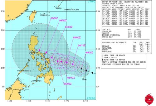
Joint Typhoon Warning Center (JTWC) an international weather agency located in Hawaii also an affiliate of United States (US) Navy has categorized tropical cyclone (Ruby) in to a super typhoon equivalent to Category 5 Hurricane which has reach the maximum wind speed of at least 130 knots or 240 kph (Kilometers per hour).
 As the latest report released by JTWC’s report at 5:00 Pacific Time, Hagupit is maintaining the route of “west-nortwestward trajectory under the steering influence of the subtropical ridge”.
JTWC also further forecast that Bagyong Ruby will be much stronger this December 7 Sunday to have a sustain wind up to 296 kph (160 knots) exactly around 2 PM when it becomes more nearer to PAR (Philippine Area of Responsibility).
JTWC weather forecast becomes a contradiction towards Japanese Meteorogical Agency that Ruby will go straight ahead and affect the Central Visayas area, which according to JTWC is will go slightly towards North Luzon avoiding the Visayas Region especially on Tacloban and Bohol area which is previously experience the collateral effect of Super Typhoon Yolanda “Haiyan”.
But local reports from PAG-ASA released a forecasted report states that Bagyong Ruby has a sustained winds of 175 kph near the center and aerial gusts of 210 kph.
PAGASA quoted that Hagupit was spotted 942 kms east northeast of Hinatuan, Surigao del Sur as of 4 a.m. It said Hagupit slowed down, moving west northwest at 25 kph.


