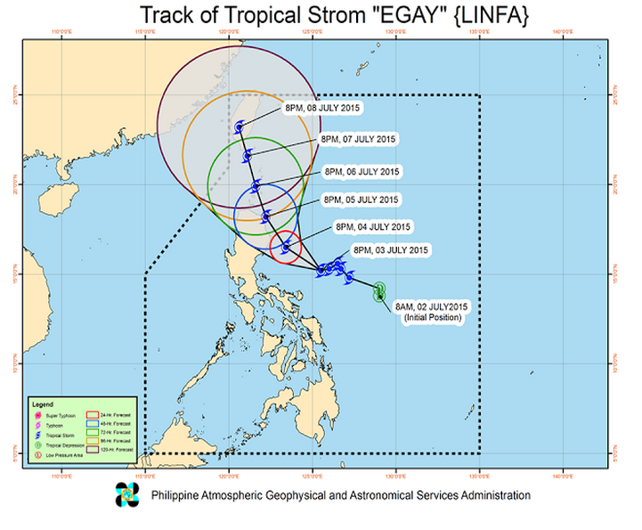
Top trending topic online! PAGASA released the latest updates on Bagyong Egay (International name Linfa). The tropical storm has intensified further as it continues to move towards the Northern Luzon. Bagyong Egay was estimated based on all available data at 395 km East of Baler, Aurora (15.2°N, 125.2°E).
It has maximum sustained winds of 85 kph near the center, gustiness of up to 100 kp and forecast to move West Northwest at 10 kph.
24 hour (Tomorrow evening, July 4): 140 km East Northeast of Casiguran, Auora.
- 48 hour (Sunday evening): 60 km East Southeast of Aparri, Cagayan.
- 72 hour (Monday evening): 170 km North of Aparri, Cagayan.
- 96 hour (Tuesday evening): 155 km Northwest of Basco, Batanes.
- 120 hour (Wednesday evening): 335 km North Northwest of Basco, Batanes
PUBLIC STORM WARNING SIGNAL
PSWS#2(61-120 kph Expected in 24 hrs.):
Luzon: (Isabela and Northern Aurora)
Wave Height: (Open Sea) 4.1-14.0 meters
STORM SURGE possible at coastal areas
Impacts of the wind:
- Light to moderate damage to high-risk structures;
- Very light to light damage to medium-risk structures;
- No damage to very light damage to low-risk structures;
PSWS#1(30-60 kph Expected in 36 hrs.)
Luzon: Rest of Aurora, Nueva Vizcaya, Quirino, Ifugao, Mt. Province, Kalinga, Apayao, Abra, Ilocos Norte, Cagayan including Babuyan and Calayan Group of Islands
Wave Height: (Open Sea) 1.25-4.0 meters
Impacts of the wind:
- Very light or no damage to high risk structures,
- Light damage to medium to low risk structures
- Slight damage to some houses of very light materials or makeshift structures in exposed communities. Some banana plants are tilted, a few downed and leaves are generally damaged
- Twigs of small trees may be broken.
- Rice crops, however, may suffer significant damage when it is in its flowering stage.
Please look at the track of Bagyong Egay (Linfa) below:


