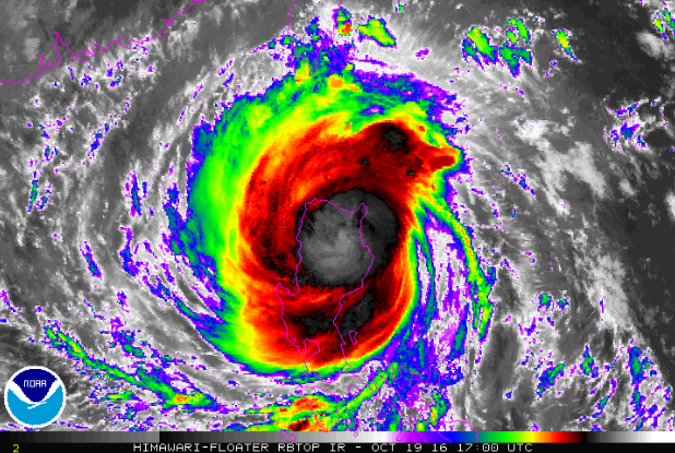
State weather bureau PAGASA stated that the Tropical cyclone “Lawin” has get down to a typhoon but is still expected to bring forth devastating winds and intense rains. Peñablanca, Cagayan, the first pathway and landfall of Lawin with a continuous winds of 225 kilometers per hour (kph) and gusts of 315 kph.
PAGASA meteorologist Samuel Duran updated us that Lawin has finally weakened it winds rate 205 kph while its gusts went down to 285 kph, in the briefing early this morning at 5 am.
Amidst of this, they still raised to signal number 5 ver Cagayan, Isabela, Kalinga, Apayao, Northern Abra and Ilocos Norte as it will still bring intense rain in it’s 800-kilometer diameter, inner ring.
Also, according to their PAGASA forecaster, “Nagbago nang kaunti ang intensity, pero destructive pa rin ang bagyo,”
He added, “Binibigyan po natin ng diin kasi ito pong northern and central Luzon ay halos mountain ranges. Prone po iyan sa flashfloods, landslides,”
List below are the the storm warning signals that has been and still raised in the following areas:
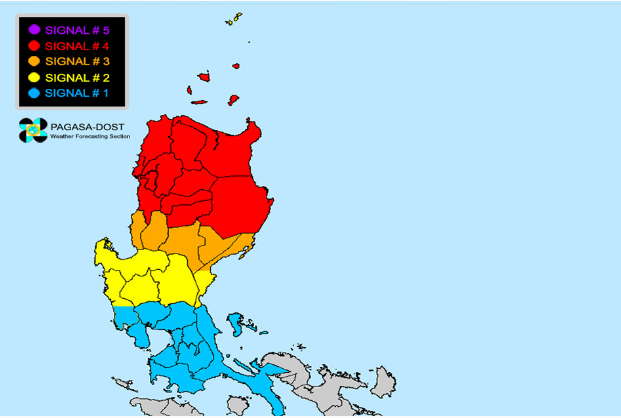
SIGNAL 4
Cagayan, Isabela, Apayao, Abra, Ilocos Norte, Ilocos Sur, Mt. Province, Kalinga, Ifugao, and Calayan Group of Islands
SIGNAL 3
La Union, Benguet, Nueva Vizcaya, Quirino, and Northern Aurora
SIGNAL 2
Batanes Group of Islands, Pangasinan, rest of Aurora, Tarlac, Nueva Ecija, and Northern Zambales
SIGNAL 1
Metro Manila, Cavite, Laguna, Batangas, rest of Zambales, Bulacan, Bataan, Pampanga, Quezon Province, and Polillo Island